“On April 8, 2015, with the stroke of a pen, the BC Government made the largest exclusion of land from the Agricultural Land Reserve in BC history,” said Hudson’s Hope Mayor Gwen Johansson, upon the release of a new interactive map which visualizes the enormous loss.
“Without Agricultural Land Commission review or public hearings, 3715 hectares (9180 acres) of ALR land was removed from production for Site C dam.”
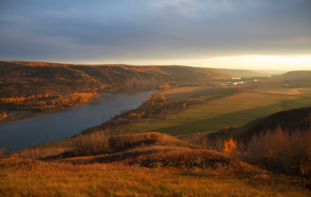
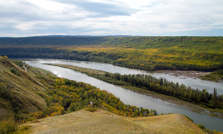
The Peace Valley is one of Canada’s most fertile regions
Yet the overall impact of the dam on BC’s increasingly scarce agricultural land base is even worse than that, according to two expert agrologists who presented their findings to the Joint Review Panel on the $9 Billion proposed project.
In all, the Site C would impact 31,528 acres of class 1-7 farmland, roughly half of which lies “within the project’s flood, stability and landslide-generated wave impact lines,” the former president of the BC Institute of Agrologists, Dr. Wendy Holm, told the 3-member panel last year. The other half will be permanently lost beneath the reservoir and access roads. Of the total land impacted and compromised, over 8,300 acres are class 1 and 2 soils – making it some the best farmland in the country.
“The Peace River Valley has extraordinarily high value for agriculture,” soil scientist Evelyn Wolterson added.
[quote]It is our opinion that the public interest is better served [by] agriculture and other uses for this valley, rather than a hundred years of power production…Power has other alternatives; agriculture doesn’t.[/quote]
Mayor Johansson agrees, especially in light of the dire drought conditions now plaguing California, on which BC depends heavily for imported produce. In fact, BC currently produces far less than half the food it consumes, according to the Ministry of Agriculture.
“The severe drought in California and the resulting increase to the cost of food we import only reinforces the need to suspend this decision and allow time for the Agricultural Land Commission to provide an independent, open and transparent review of the exclusion decision,” commented Johansson in passing along the new interactive map to media.
The map enables users to compare the loss of land in BC’s Peace River Valley from Site C with what it would look like in other major farming regions in the province, includingRichmond, Victoria, Kamloops, Prince George, Kelowna and Chilliwack.
Said Johansson, “…this single land exclusion is equivalent to removing an area equal to 72% of all ALR land in Richmond, BC.” According Holm and Wolterson, the land being taken out of potential agricultural production could feed up to a million people – or close to a quarter of the province’s population.
While the BC Liberal government has approved the project and stands by its goal of starting construction this summer, Site C is currently facing no fewer than seven legal challenges from First Nations and farmers.
California’s Central Valley is facing record drought conditions
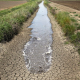
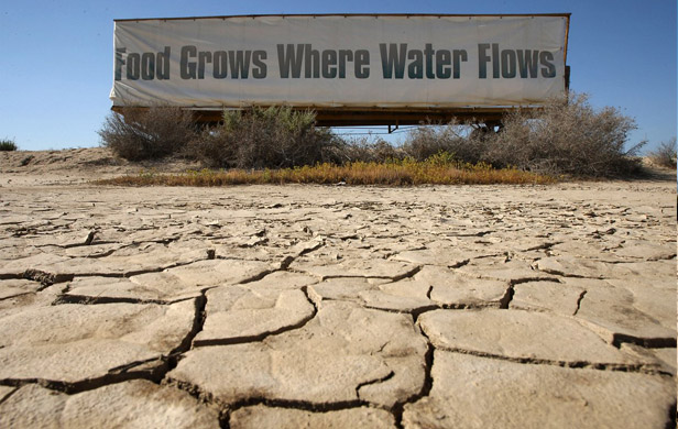
As British Columbians share a meal this weekend, giving thanks for the food with which we are so blessed, year-round, let us pause for a moment to consider where so much of it comes from: California.
Let us also say a prayer for the last truly productive tracts of local farmland we have left, now threatened by industrial development – first and foremost being the Peace River Valley, in northeast BC, where the proposed Site C Dam could wash away enough good agricultural terrain to feed a million people.
BC depends on food imports
The fact is BC now grows less than half of the food it consumes, and the places we depend on for our imports may not be able to continue providing them into the future. As Randy Shore pointed out in the Vancouver Sun this past Friday, a record drought in California may drive up food prices in BC by as much as 34% this year.
Shore was referring to a recent study commissioned by Vancity on BC’s food security. Says the study’s author, Brent Mansfield of the UBC faculty of land and food systems:
[quote]As the drought deepens in California and elsewhere, we need to understand what that means for consumers, for governments and for the business of agriculture here in B.C.[/quote]
With 67% of of our fruits and vegetables now being imported from the US – and half of that from California – BC is vulnerable to changing conditions amongst those suppliers. Thus a severe drought in California’s Central Valley means British Columbians should brace for paying 34% more for Californian lettuce and 22% more for broccoli, according to the University of Arizona and University of Guelph.
Then why flood our best farmland?
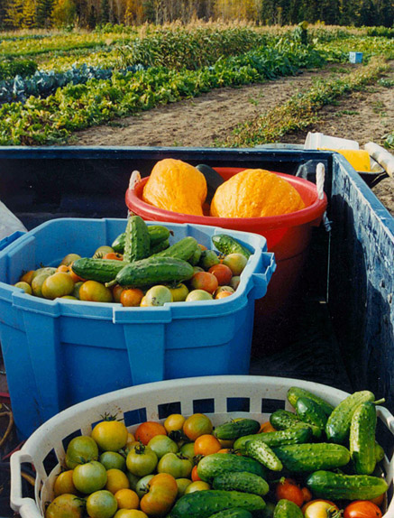
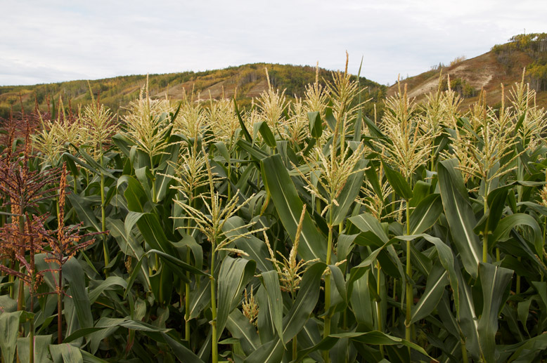
A sampling of the diverse produce grown at the Peterson market garden in the 1980s (photo: Larry Peterson)
Site C – this $8 billion-plus, taxpayer-funded dam that would increase our provincial debt by more than 10% and won’t benefit the people or businesses of the province one iota – would cause the single largest loss of farmland in the history of the Agricultural Land Reserve. It would drown or disrupt over 30,000 acres of amazing farmland.
Of course, the Agricultural Land Commission – the public’s supposedly arm’s length watchdog whose job it is to review and often oppose such planned assaults on our food security – was barred by a meddling government from reviewing Site C.
For starters, the Peace River’s largely east-west orientation means the valley gets more sun, thus experiencing longer growing days and seasons than other land that far north. “The best farmland in BC is in the southern valleys,” expert agrologist Evelyn Wolterson told the review panel. “The notable exception is the Peace River Valley.”
Other factors like lower wind speeds, excellent Spring moisture, and a longer frost-free period mean, counterintuitively, that “crop yield goes up as you go from the south to the north,” Wolterson explained.
[quote]These are all elements of this valley that make it absolutely unique…not only in the region but in all of British Columbia, and perhaps Western Canada.[/quote]
These factors, combined with high-grade alluvial soils mean the Peace Valley can rival and even exceed the Lower Mainland’s Fraser Valley breadbasket for productivity.
For instance, Larry Peterson, who ran a successful market garden in the Peace Valley with his wife Lynda in the 1970s and 80s, got 13.6 tonnes per acre for potatoes, compared with the average yield in the Lower Fraser Valley of only 10.2 tonnes per acre.
Hydro downplayed Valley’s value
The valley’s agricultural attributes have been “very dramatically” downplayed by project proponent BC Hydro, says Wendy Holm, a former president of the BC Association of Agrologists.
[quote]The land to be flooded by Site C is capable of producing high-yielding fresh fruits and vegetables for over a million people.[/quote]
Yet Hydro and the BC government act like Site C’s impact on farmland is small potatoes.
The reality is the large flood reserve Hydro has been accumulating for years – buying up farmland throughout the region and sitting on it in preparation for the dam – coupled with the spectre of the project that has loomed over the valley for over 3 decades now, have severely constrained local agricultural investment and development, creating a false picture of the region’s potential for food production.
So this Thanksgiving, as we pass the Brussels sprouts that are actually from California, let us take a moment to reflect on the value of healthy, local food production. And then, after the turkey-induced haze has worn off, tell the Harper Cabinet – in advance of its anticipated Oct. 22 ruling on Site C – that flooding our best remaining farmland for energy we don’t need just plain doesn’t make sense.
The Peace River Valley is one of Canada’s most fertile regions (Damien Gillis)
Keeping the Peace Valley’s farmland and ecosystems intact would be worth $7.9 billion to $8.6 billion a year, says a new study from the David Suzuki Foundation.
Region’s ecosystems provide many valuable services
Industrial impacts throughout Peace region – indicated in red (from previous DSF report)
This latest report, which involved 3 years of intense data collection, analysis and review, tabulates the economic value of preserving what remains of the valley’s natural values. “These ecosystems play a critical role in providing clean air, clean water, habitat for wildlife and many other ecological benefits that sustain the health and well-being of local residents, and contribute to the cultural and traditional ways of First Nations,” says DSF.
The services provided by the 5.6 million-hectare region’s diverse ecosystems include “water supply, air filtration, flood and erosion control, habitat for wildlife and agricultural pollinators, carbon storage and other benefits.”
“We’re concerned because the strain on the Peace River Watershed’s farmland and natural ecosystems will only increase with the B.C. government’s plan for increased oil and gas development, including liquefied natural gas, as well as large infrastructure projects such as the proposed Site C Dam,” says the Foundation’s Dr. Faisal Moola.
Farmland could feed a million people
At the environmental assessment hearings into the $8 Billion proposed Site C Dam, expert agrologists Wendy Holm and Evelyn Wolterson told the Joint Review Panel that the land in the proposed flood and impact zone could feed a million people. This is due to the extraordinary soils and climate conditions of the valley, Wolterson explained.
[quote]These are all elements of this valley that make it absolutely unique…not only in the region but in all of British Columbia, and perhaps Western Canada…It is our opinion that the public interest is better served [by] agriculture and other uses for this valley, rather than a hundred years of power production.[/quote]
$7 Billion/year in carbon sequestration
The Suzuki report also calculates the value of the region’s forests, grasslands and wetlands in terms of carbon storage, pegged at $6.7 billion to $7.4 billion a year, with other ecosystem services contributing $1.2 billion a year.
Says Moola, “…our study shows that remaining farmland and natural areas have an incredible ability to generate natural wealth.”
[quote]We’re concerned because the strain on the Peace River Watershed’s farmland and natural ecosystems will only increase with the B.C. government’s plan for increased oil and gas development, including liquefied natural gas, as well as large infrastructure projects such as the proposed Site C Dam.[/quote]
Site C review panel worried about cumulative impacts
While the Joint Review Panel opted not to render a definitive verdict on the dam in its report, released in May, it did echo DSF’s concerns about the cumulative effects of multiple projects in the region, compounding the dam’s impacts. “Whether the Project proceeds or not, there is a need for a government-led regional environmental assessment including a baseline study and the establishment of environmental thresholds for use in evaluating the effects of multiple, projects,” the Panel stated.
First Nations back report
Chief Roland Wilson of West Moberly First Nations echoed the Suzuki Foundation report, noting that his people “have been blessed with forests, rushing rivers and rolling grasslands that have sustained our communities for thousands of years. However, the cumulative effects of industrial development in our territories have been massive and can’t be mitigated. They’ve had an enormous impact on our treaty rights as First Nations people.”
According to Moola, various aboriginal representatives helped guide the Suzuki report with their traditional knowledge of the area. “First Nations helped decide the study area, identify data sources, and review the work – including ensuring that we accurately reflected the place names, and other references to their Dane_Zaa culture”.
Many of these aboriginal voices are represented verbatim in the 2013 DSF-published report, Passages for the Peace, which includes interviews with elders, hunters, artists and other community members describing the role the land plays in their lives and the value of natural capital in their culture and economy.
The federal Cabinet is expected to render a decision on the dam in September. Says Moola, “We hope this report encourages discussion about how natural areas and farmland in B.C.’s irreplaceable Peace Region are valued — and undervalued — when decisions are made that could destroy the region’s natural wealth.”
Former BC Environment Minister Corky Evans (Photo: Alex Hanson)
An Open Letter to Almost Everybody:
My name is Corky Evans. I garden and farm in the Kootenays of B.C. Many years ago I was the Minister of Agriculture.
I do not understand popular culture or electronic communication. I have not learned to do Facebook. What I have been told is that when people find something interesting from someone they trust, they send it on to other people and in this way it is possible to engage more people, faster, than ever before.
I am not going to try to explain the issue or the history or the legislation that is being debated in Victoria as I write. You do not have to know that stuff to know that food is important and that land to grow food on needs to be protected from being paved over. That is all you need to know. For forty years we have had rules in B.C. that protected farm land pretty well. This week the Government is trying to pass a law that will destroy the protection of farmland.
I think lots of the MLAs in Victoria know this law they are debating is a bad law. The law is opposed by Greens, New Democrats and Independents. They are, as I write, trying to delay passage to give citizens a chance to learn what is happening and react. I think it also opposed by some Liberal members who are too afraid to speak publicly.
You can research everything I am saying if you have time. If you don’t have time, and if you got this letter from someone you trust, I beg you to take 5 minutes to try and stop this law. I do not care, by the way, if it is stopped forever. I just want it stopped until citizens understand what is happening and get to have a say before the Government wrecks something of great importance for our shared future.
Take action
If you have 5 minutes here is what you do: You look in the phone book for the number of your MLA and call them and say you don’t want them to pass Bill 24. Or you send them an e-mail by looking here to find their address. Then you send this request to the people who trust your judgement enough to read it.
This probably won’t work. I am asking, though, because nothing else will. In a week or so we will all know how it turned out.
The Peace River Valley is one of Canada’s most fertile regions (Damien Gillis)
A pair of highly-respected agricultural experts made a compelling case this week for sparing some of BC’s best farmland from a proposed dam on the Peace River. Together, veteran agrologist Wendy Holm and soil scientist Evelyn Wolterson argued that BC Hydro’s error-ridden study of the flood zone for the $10 billion proposed Site C Dam missed the unique soil and climate values that would enable this land to feed up to a million people – were the focus to shift from hydropower to farming.
Conversely, if a third dam on the Peace were built, it would create the single largest loss of land in the 40-year history of the province’s Agricultural Land Reserve (ALR) – drowning or severely impacting over 30,000 acres of largely exceptional land.
On Tuesday, the Joint Review Panel investigating Site C heard from Holm, a highly-decorated former President of the BC Institute of Agrologists with 40 years’ experience in the field, and agrologist and farming consultant Evelyn Wolterson – both presenting their findings on behalf of the Peace Valley Environment Association and BC Women’s Institue.
“The Peace River Valley has extraordinarily high value for agriculture,” Wolterson told the panel from the outset.
[quote]It is our opinion that the public interest is better served [by] agriculture and other uses for this valley, rather than a hundred years of power production…Power has other alternatives; agriculture doesn’t.[/quote]
Over 30,000 acres to be flooded or impacted
Location of the proposed Site C Dam (Damien Gillis)
In all, the project would impact 31,528 acres of class 1-7 farmland, roughly half of which lies “within the project’s flood, stability and landslide-generated wave impact lines,” notes Holm’s report to the panel. The other half will be permanently lost beneath the reservoir and access roads. Of the total land impacted and compromised, over 8,300 acres are class 1 and 2 soils – making it some the best farmland in the country.
According to Holm, Hydro ignores the half that won’t end up under water immediately but will nevertheless be heavily compromised over time and rendered largely un-farmable. Meanwhile, in its Environmental Impact Statement (EIS) for the project, the crown corporation determines the loss of the other half “is insignificant, because all ‘costs’ associated with any such loss can be mitigated and/or compensated.” Holm charges that the crown corporation understates everything from the amount of land impacted, to the long-term damage from the project to the local farming economy.
And that’s just the beginning of the problems with BC Hydro’s EIS which Holm and Wolterson unearthed for the panel.
The Peace Valley’s surprisingly “extraordinary” land
The panel seemed genuinely interested to learn from Holm and Wolterson about the special properties of the valley that make it so productive agriculturally.
For starters, the Peace River’s largely east-west orientation means the valley gets more sun, thus experiencing longer growing days and seasons than other land that far north. “The best farmland in BC is in the southern valleys,” Wolterson told the panel. “The notable exception is the Peace River Valley.”
Other factors like lower wind speeds, excellent Spring moisture, and a longer frost-free period mean, counterintuitively, that “crop yield goes up as you go from the south to the north,” Wolterson explained.
[quote]These are all elements of this valley that make it absolutely unique…not only in the region but in all of British Columbia, and perhaps Western Canada.[/quote]
Even a BC Hydro representative acknowledged to the panel in an earlier presentation Tuesday, “Our assessment certainly accepts that this is highly capable land and a favourable climate.” If anything, he conceded, the climate has improved since the last major study conducted by BC Hydro 30 years ago.
Yet throughout the project proponent’s 15,000-page report, “flawed data is leading to faulty conclusions,” Wolterson asserts.
Hydro cultivates wrong idea about valley’s farmland
A sampling of the diverse produce grown at the Peterson market garden in the 1980s (photo: Larry Peterson)
Both experts ticked off a long list of problems with Hydro’s methodology for the EIS. “The panel does not have in front of it reliable information on which to measure the economic loss to agriculture and the public interest,” Holm stated at the top of her presentation.
Wolterson gave several examples of BC Hydro’s flawed analysis. For instance, a higher-elevation region above the valley known as the Uplands was given roughly same growing season as a monitoring station at the Fort St. John Airport, while the dam proponent ascribed 30 fewer growing, or “crop opportunity” days to the valley itself. “There’s something wrong with that data,” Wolterson told the panel.
“What it shows here is the capability of these [valley] lands in Attachie Flat and Bear Flat are equivalent to what they are at the Fort St. John airport. I’ve worked in this community for 20 years…I know that’s not true,” Wolterson testified, offering an example of crop yields 30% higher in the valley, compared with farms closer to Fort St. John.
In some cases, the valley beats even the Lower Mainland’s farms for productivity. For instance, Larry Peterson, who ran a successful market garden there with his wife Lynda in the 1970s and 80s, would get 13.6 tonnes per acre for potatoes, compared with the average yield in the Lower Fraser Valley of only 10.2 tonnes per acre.
In broader terms, Holm emphasized:
[quote]The land to be flooded by Site C is capable of producing high-yielding fresh fruits and vegetables for over a million people.[/quote]
BC’s food security withering on the vine
“There is a misperception that there is a vast amount agricultural land that is waiting to be exploited. It’s simply not true,” Wolterson warned the review panel.
Much of the Peace Valley’s best farmland was flooded in 1968 by the WAC Bennett Dam (Damien Gillis)
According to the Ministry of Agriculture’s own 2007 assessment, titled BC’s Food Self-Reliance (download here), BC grows just 48% of the food it consumes. Vegetable production per capita has fallen to half of what it was in 1970. And the problem is only getting worse, says Wolterson. “Over the last 10 some-odd years, there’s been a serious and alarming decline in agricultural land area” – driven by everything from urban encroachment, industrial projects, and declining of productivity.
The combination of a shrinking food supply and growing population has put BC on a path to serious food security challenges, both presenters emphasized.
In that sense, Site C Dam should be viewed in the context of a wide range of cumulative impacts, together whittling away BC’s food security. Issues like fracking, roads, and segmentation of farmland for other industrial projects have all made farming more difficult and dragged down productivity, says Wolterson.
Moreover, BC Hydro’s flood reserve – a land bank it has accumulated over the years, buying out farmers in preparation for a future dam (Site C has been on the books for three decades now) – has had an “enormous”, detrimental impact on agricultural investment in the valley, giving a false impression of the productivity of the land. Hydro’s EIS and rationale for the dam leans heavily on this fiction.
Economic value of farmland underestimated
Cash crop: Is Hydro underestimating the economic value of farmland?
Holm’s presentation focused in part on the economic value Hydro assessed to farmland that would be lost from the dam, arguing it has made some dangerous miscalculations. With “global loss of farmland, water shortages, soil salinization, higher energy costs, transportations costs, supply chain concentration, population growth, there is no question that there is going to be intense pressure on food prices as we move into the future,” cautioned Holm.
In other words, land that is fallow and of seemingly little value today could see its economic worth – and value as a local food source – skyrocket in the future, something we may rue when we can no longer depend on truckloads of cheap tomatoes from California rolling across the border.
British Columbians currently spend 11% of household income on food, Holm noted, but that figure could rise significantly in the not-too-distant future, based on these myriad shifting factors. Viewed in that light, Hydro is recklessly lowballing lost economic value from flooded farmland, pegging it a a paltry $20 million.
The Shadow of the Dam
Holm came back to the flood reserve issue as well, suggesting that Hydro’s assumptions of the productivity and economic value of the land are erroneously based on a false dynamic that discourages farmers from working the land to its full potential.
[quote]The ‘shadow of the dam’ refers to the flood reserve that fell across the farmland in 1957. Considerable farmland was purchased by BC Hydro, farmers were told not to get too attached to their fields as Site C moved on, then off, then on again to the provincial drawing boards. Naturally, this has prejudiced farm decision-making. As a result, current land use does not reflect the agro-economic potential of the land.[/quote]
“This independent body, which was specifically created to ensure a thorough, non-partisan assessment of large projects like Site C, is not going to be allowed to do its job,” says Peace Valley Environment Association (PVEA) Coordinator Andrea Morison. The PVEA wrote to the Joint Review Panel, suggesting it ask the ALC for details on the process that they would have undertaken in assessing Site C – despite the provincial government’s attempts to exclude it from the conversation. The panel declined the request.
And so it is that both public watchdogs designed to keep the government and Hydro in check in this very situation curiously find themselves sitting on the bench for the biggest game of their careers.
Even the public hearing process was scheduled over the holiday season and limited to the region of the dam, despite the enormous bill taxpayers around the province would foot to build it. The whole process has been anathema to public participation.
Hydro’s work “weak and meaningless”
In the ALR’s place, BC Hydro has done a predictably poor job of assessing these agricultural issues and planning for their mitigation, say Holm and Wolterson.
“BC Hydro acknowledges that the mitigation plan and the compensation program that they’ve put together…they don’t really know how much is needed; there’s no specifics in how it would be implemented; there’s no evidence of possible uptake; there’s no proof that there’s a benefit,” Wolterson said in her conclusion.
[quote]I think it’s weak and I think it’s meaningless and it gives me no confidence and I can’t see how the panel can determine if this plan is going to adequately compensate for the loss of these incredibly valuable lands.[/quote]
What’s more important: energy or food?
Arlene Boon’s family would lose its century old farm at Bear Flat to Site C
Beneath the 15,000-page reports, the political shenanigans with the review process, and all the rhetoric about economic development lies a simple truth: Last year, BC generated about 110% as much electricity as it needed, but produced, at most, 48% of the food it consumed. In other words, while we have plenty of electricity to power our homes and businesses well into the future, the same thing cannot be said about our food security.
The problem is virtually invisible to British Columbians today. Most of us have no idea we exported a net surplus of 5,840 gigawatt hours of power last year (at a loss!) – you certainly wouldn’t learn this listening to BC Hydro, which has a long history of exaggerating future demand. And as long as those trucks keeping rolling north from California and Mexico – as long as Superstore’s shelves remain stocked and Costco keeps selling giant bags of tri-coloured peppers for 5 bucks – most of us will never know how real the danger is, how foolish the choices are that our government is making today.
So the choice we face with Site C Dam – if you can even call it a choice for BC’s marginalized citizens and First Nations – is this: Power that we don’t need…or food that we do?
The days of the family farm are numbered if we don’t act to protect BC’s ALR now, says ex-Minister Corky Evans
by Corky Evans
Imagine that you might, someday, want to farm for a living. Or imagine your kids might want to farm, or your grandkids. All over the world such dreams become harder and harder to achieve as land capable of supporting crops is paved over for roads or built into shopping centers or houses or is used for industry.
In B.C. during the 1960’s and early 70’s, we lost 6,000 acres of farmland every year to subdivisions and other non-farm activities. In 1972 there was a provincial election and farmers came together to ask all of the parties to do something about the preservation of farmland before it was all gone. Every party responded to those concerns by talking about various solutions they might enact should they win the election.
Farm protection grows with birth of Agricultural Land Reserve
In 1973 the new Government created the Agricultural Land Reserve to protect land capable of producing food. The new law was tough, and owners of land who wanted the right to sell it for subdivision or some other use were surprised and angry. Surprised because such zoning laws are rare in the whole world, and angry because if they ever decided to stop farming, they would only be able to sell their land as farmland (not to developers from whom they could make much more money).
But the people of B.C. liked the idea of protecting farmland and, surprisingly, the law has remained on the books and functioning for four decades. Thus, if you or your kids or your grandkids want to farm someday, or if you want to be able to buy food from people who live and farm near you, B.C. is a good place to live to make those dreams come true.
Tough road to hoe for Commission
The outfit responsible for supervising the Agricultural Land Reserve is called the Agricultural Land Commission and it is a group of people appointed by whoever is the Government of the day. They have the very hard job of receiving applications from owners of farmland for various uses and deciding what is good for the protection of farming and what is not.
Back in the late 1990’s I was honoured to be the Minister of Agriculture. My friend John van Dongen was the Opposition Critic of Agriculture for the Liberal Party.
One day John rose in the Legislature and accused me of Conflict of Interest in a case being considered by the Agricultural Land Commission. Conflict is a serious charge. A Minister can, and should, lose their job if they are guilty of Conflict. Even just the accusation of Conflict implies the possibility of a serious breach.
I could tell from John’s expression as he raised the issue that he didn’t believe his claim to be true. And I knew it wasn’t true and, later, the Conflict of Interest Commissioner would research the charge and find it was wasn’t true.
While I was not, legally, guilty of wrongdoing or Conflict, John’s accusation was, nevertheless, justified. My point is that the relationship between any Government of British Columbia and the Agricultural Land Commission is always fraught with difficulty. Provincial Ministers charged with representing the interests of the Crown are, under any administration, frequently skating on the edge of real Conflict in their dealings with the Commission.
But it cannot be otherwise. The Agricultural Land Commission is charged with doing the work of the Angels in protecting land capable of producing food from development. Conversely, the Government of the Province is charged with doing the work of the Devil in trying to make development happen in order to sustain an economy and employ people and get themselves re-elected. The interests of the two are at odds with each othereven in times when the Government of the day is supportive of the Agricultural Land Reserve in principle.
BC’s ALR a world-renowned model for food security
I live and produce food on land that I purchased prior to the creation of the ALR and still own. I love the Agricultural Land Reserve and hugely admire the politicians who had the guts and the foresight to put it into law so many decades ago.
When I had the honour to serve as Minister of Agriculture of B.C. I received separate visits from farmers from Ontario, Alberta, Tennessee and New Mexico who traveled all the way to our Province to ask our advice. They all wanted to know how they might develop a similar law to protect their livelihood, threatened as it was by various forms of encroachment into farmland by other interests.
In every case I had to tell them that I did not know how they could enact such legislation in the face of modern pressures that would oppose them.
I also told them that if they could achieve sufficient political will to consider such legislation we would, of course, assist them in any way we could to write or to debate such legislation. But, I said, sufficient political will in this day and age was hard to imagine. If we hadn’t seen fit to pass the law protecting farmland in 1973 there is no way we could manage to do so now.
Right-wing think tank plants seeds of ALR’s demise
Such is the debt that we, British Columbians, owe to those who made the ALR in the 1970’s. It was possible then to consider such a vision, policy and law. It is almost unfathomable today to imagine a government, anywhere, achieving a similar objective.
A few years ago, a B.C. organization that speaks for corporatist values, the Fraser Institute, commissioned a report calling for an end to the Agricultural Land Reserve. The report disparages both Canadian farmers and consumers of food who desire to purchase food produced locally. The report is online and it is worth reading to understand that your dreams or your values may run counter to those of some people with a great deal of power in our society (download full report).
Following the publication of that 2009 report, we had an election in B.C. While the issue of the future of the Agricultural Land Reserve was not an issue in the election, the Government that won the election appears to have decided to support the ideas of the Fraser Institute.
Time to speak up for agricultural land
That is why it is time for all of the people in the province who produce or eat food to rise up and defend the Agricultural Land Reserve. If we weaken it now, it will die.
Although the Land Reserve may have been visionary and, therefore, hard for some people to accept way back in 1973, I think it’s time may have finally come. Everywhere I go people are beginning to talk about food and the quality of food and where it comes from and how it is produced. Young people, for pretty much the first time in my 65 years, are talking about wanting to learn to farm for a living. Village, town and city people are often even more interested in food issues than my neighbours in the rural area.
This might be the moment when both urban and rural people could build a coalition of consumers and producers to defend farmland and support farmers that would define public policy in B.C. for decades to come.
An issue of values
At this moment in history, when everyone from the Fraser Institute to the Provincial Government seems to want to do away with the ALR, or manipulate it to serve their interest, the situation reminds me of that line we hear at weddings, the one that says “Speak now or forever hold your peace.”
This is not a partisan issue. New Democrats wrote the law in 1973. It was sustained by Socreds for a quarter century. When John van Dongen rose to defend the Commission in the 90’s, he was a Liberal. I know lots of farmers and discerning consumers who vote Green. One of the strongest voices in defence of the ALR in the Legislature, Vicki Huntington, is an Independent. This issue isn’t about your politics, it is about your values. Either your values, or those of the Fraser Institute.
Let’s choose to speak. Loud and from everywhere, with no urban/rural difference, in support of the Agricultural Land Reserve and in support of the producers who work that land.
What you can do
And if you are moved to speak I have thoughts about how you might go about it. First, send this or some writing of your own to everyone you know who eats, gardens or farms to let them know what’s happening.
Second, take an old-fashioned pen and some paper and write your thoughts in a letter to the Premier of British Columbia. Your own thoughts. Do not bother with the Ministers whose names have been attached to this issue. Ministers are supposed to try “trial balloons” to see if they are accepted by the public. They will not be the ones who decide whether or not to mess with the Land Reserve. The Premier will make that call. Do not bother sending her an e-mail. E-mails do not make a stack on anybody’s desk. E-mails are not given the weight of a letter that you write yourself. A big stack of letters will not go unnoticed.
This issue will be resolved, one way or another, by the spring. Now is the time to choose to speak.
Corky Evans is a retired BC NDP MLA for Nelson-Creston and provincial agriculture minister.
Public interest group IntegrityBC is calling for the resignation of Liberal Agriculture Minister Pat Pimm, following the revelation that he and Fort St. John Mayor Lori Ackerman meddled in an Agricultural Land Commission hearing into removing a piece of farmland from the ALR.
The Globe and Mail’s Mark Hume reported on Saturday that Peace River North MLA Pimm was rebuked by the Commission for advocating for an application which it ultimately rejected in August. In the same ruling, the Commission criticized Pimm and Ackerman’s political interference in the arm’s-length review process. Said the ALC:
[quote]In our respectful view, those representations were not appropriate. They could create the impression for both the Commission and the public that these officials were attempting to politically influence the Commission.[/quote]
Pimm weighed in on an application by Terry McLeod to build a rodeo ground and campsite atop “high agricultural value” Class 2 soils on his 70.66-hectare farm.
The revelation of Pimm’s interference comes on the heels of another recent story by Hume, which unleashed a wave of controversy over a leaked Liberal memo in which Pat Pimm calls for the gutting of the ALC’s powers to clear the way for oil and gas development.
In a press release on the lastest controversy related to Pimm, Integrity BC calls for the Minister’s resignation, pointing to a similar incident which forced federal Conservative Minister John Duncan to step down from Cabinet earlier this year. Duncan was found to have intervened in a Tax Court hearing on behalf of a constituent in 2011.
“This is politics 101,” says IntegrityBC executive director Dermod Travis.
[quote]Ministers don’t interfere in the work of judicial or quasi-judicial tribunals and – if they do – they resign.[/quote]
Travis told the Georgia Straight today that he’s “flabbergasted” the NDP Opposition hasn’t yet echoed his call for the Minister’s resignation.
IntegrityBC has also launched an online petition calling for the Liberal Government to halt the gutting of the ALR contemplated in Pimm’s recently-leaked memo. The petition has garnered over a thousand signatures in just a few days.
ALR co-founder Harold Steves on his family farm in Steveston, BC (Damien Gillis)
VANCOUVER – A leaked cabinet document that proposes significant changes to British Columbia’s Agricultural Land Reserve — millions of hectares of cherished farmland that have been largely protected from development for decades — prompted swift denials Thursday from the provincial government and left proponents of the program with uneasy questions about its future.
The Globe and Mail published a story based on cabinet documents that reportedly outline a proposal from Agriculture Minister Pat Pimm to “modernize” the Agricultural Land Commission, the Crown agency that manages the land reserve.
Gas before food
Among other things, the proposal would see the Agricultural Land Commission cease to be an independent agency, instead coming under the control of the Agriculture Ministry, while handing “primary authority” to authorize industrial activity on agricultural land to the B.C. Oil and Gas Commission, the newspaper reported.
The documents were prepared as part of a so-called “core review” of government operations, launched earlier this year in a bid to trim the provincial budget, and the cabinet minister in charge of that review responded Thursday by ruling out many of the most controversial aspects of the leaked proposal.
Minister downplays concerns
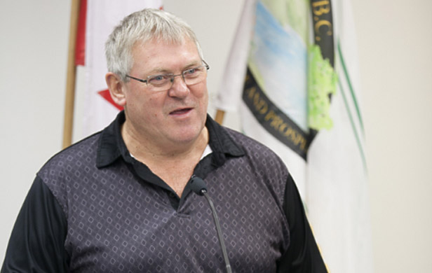
Bill Bennett, who is also the minister of energy and mines, said the Globe and Mail story was based on an “older document” that has since been rejected. He said the government has ruled out shifting the commission’s duties to the agriculture minister or handing over more decision-making authority to the oil and gas regulator. Said Bennett in an interview:
[quote]We certainly have no plans to bring the commission inside government or tamper with the independence of the commission, and we have no plans to undermine the central principle of the reserve, which is the protection of good quality farmland.[/quote]
Bennett noted the B.C. Oil and Gas Commission has had the power to approve certain applications on land within the Agricultural Land Reserve for nearly a decade through a document known as a “delegation agreement,” which was last updated earlier this year.
“If there were changes made (to the agreement), they would be quite minor; we’re not looking at anything close to what the reporter described in his article.”
Bennett downplayed the significance of Pimm’s proposal, suggesting it was little more than one of many ideas he and his Liberal government colleagues have considered as part of the core review process.
However, Bennett’s comments did little to assure supporters of the land reserve, which was created in the mid-1970s by the NDP government of the day amid concerns that the province’s farmland was rapidly disappearing.
40-year-old ALR fiercely defended
The reserve is made up of 4.7 million hectares of land throughout the province on which agriculture is given top priority. Strict controls are placed on non-agricultural uses and under what circumstances land can be taken out of the reserve.
The Agricultural Land Reserve is one of the most fiercely defended institutions in the province, with advocates routinely raising concerns that private businesses — whether through property development or oil and gas projects — have been able to whittle away at protected farmland.
Those fears have persisted despite the provincial government’s repeated insistence it has no plans to gut the reserve. Earlier this year, the government added $4 million to the Agricultural Land Commission’s budget over the next three years.
Father of the ALR weighs in
Harold Steves, who as an NDP member of the legislature in the 1970s is credited as one of the land reserve’s co-founders, said he’s convinced the Liberal government is searching for ways to weaken the reserve and the commission that protects it.
“I’m not confident at all,” said Steves, who is now a city councillor in Richmond, south of Vancouver.
[quote]Whether they’ve ruled these two particular proposals out, I would bet there’s another one some place, and we’ll just see them coming one after another.[/quote]
Steves warned any attempt to tamper with the land reserve would be fraught with political danger.
“If they called an election on this issue, they wouldn’t get a seat,” he said.
NDP fires back
The Opposition New Democrats were quick to seize on the leaked cabinet documents, holding them up as proof the Liberals are bent on destroying the land reserve in favour of big business.
NDP Leader Adrian Dix said the Agricultural Land Commission has done a good job protecting the land reserve, and he accused the Liberals of “attacking the independence” of the agency.
“It’s extraordinary — it’s really a betrayal of what the Liberals have said,” Dix said in an interview.
[quote]In secret, they’re talking about undermining it. It doesn’t make sense, it’s not needed, it’s not clear what problem they’re trying to solve, and it would be a victory of private interests over the public interest.[/quote]
Cattlemen’s beef with slaughtering ALR
Industry groups such as the B.C. Cattlemen’s Association and the B.C. Agriculture Council said they were concerned about the leaked cabinet proposal, but they acknowledged they still need to see more details about what changes, if any, the government is actually considering before coming to any conclusions.
They also expressed frustration their members haven’t been consulted about the future of the commission.
Rhonda Driediger, the chair of the agriculture council, said the government needs to come up with a detailed vision for the province’s agriculture industry before making any substantial changes to how the land reserve is managed.
“The Liberals have not really given us a long-term plan for agriculture,” said Driediger.
“If we had a long-term agriculture strategy, we wouldn’t even be having this conversation.”
Dana Maslovat of Southlands the Facts near the contentious Southlands property in Delta, BC
Canada’s most contentious piece of farmland is back on the chopping block as the Corporation of Delta held another in a long line of public hearings into the Southlands property in recent weeks. Debate over the property in the early ’80s yielded the longest public hearing in Canadian history.
On the table today is a revised plan to develop the 500-acre parcel in Boundary Bay for 950 homes. Council closed debate after 5 days of hearings, throughout which 233 people spoke in opposition to the application and 163 in favour.
Of the 2,348 pieces of written correspondence received to date, 1,477 were opposed, with just 871 in favour. Council is set to reconvene Friday to decide on formally closing the hearing process. According to the Delta Optimist, “A special meeting will then commence to consider further action.” Council can vote the project down or decide to refer it to Metro Vancouver, who would also need to remove the property from its regional Green Zone for construction to proceed.
Erosion of democracy
It’s been more than three decades since the Southlands (a.k.a. Spetifore Farm) was removed from the Agricultural Land Reserve by the Socred Government – against the Commission’s advice – prompted by a group of Socred insiders seeking to develop it. Ever since, a battle has raged in the community over various plans to build atop this fertile piece of land.
Builders dismiss its agricultural potential, but soil reports tell a different story. A 217 acre portion of the property was farmed for 40 years and some of it is farmed today – 80 acres for potatoes and barley, plus a popular community garden called Earthwise (see video below).
More than the potential erosion of good, food-producing land, perhaps the biggest issue with the Southlands has been the erosion of local democracy. No development proposal in Canada has faced a longer, more steady, more intense wall of community opposition than the Southlands.
Citizens have lined up at one hearing after another, filled out questionnaires, responded to polls, always with the same message, by a considerable majority – reflected again in the numbers for this latest round of public feedback. They want the property maintained for agricultural use and wildlife habitat.
“Yet again the community has indicated their staunch opposition to this development plan,” says Dana Maslovat of Southlands the Facts, following the recent outpouring of community opposition to the project.
[quote]In the last four years, citizens have been asked again and again if they would support development on the Southlands and each time the answer has remained a resolute “NO!”…It has left the community doubting that this Council and Mayor ever intended to conduct a fair and transparent assessment. [/quote]
The municipality spent several years developing a core planning document to guide development – the Tsawwassen Area Plan – which doesn’t support the development of the Southlands. Yet, two years ago, the owner sought to override that plan for its development. I produced this short documentary on the subject at the time:
Back in 2011, the Municipality of Delta was considering an appeal from owner the Century Group to change the zoning from agricultural to residential (though the property was removed from the ALR years ago, it has retained its municipal agricultural designation). When hundreds of citizens turned out to oppose the move through multiple nights of hearings, the development stalled again.
Maslovat and his allies are frustrated that tax dollars are being used to provide the developer with what seems like an unlimited number of chances to re-submit its application. “It’s the citizens who are paying for this process, time and time again,” Maslovat told me.
Ministry of Agriculture staff critical of plan
The developer has since downgraded its proposal from 1,900 to 950 homes, with a 172 hectares set aside for farmland and public space. Century Group boss Sean Hodgins defends the new application, claiming, “The plan is different, in that it was configured more to the south and now it’s more to the east in response to the soil quality.” The developer’s plan incorporates a “Community-based farming model”, which purports to educate the public about farming by locating small plots near the development.
But Ministry of Agriculture staff are skeptical, outlining their concerns in a letter to mayor and council. They note a report by the developer “does not contain enough details regarding soils, suitable crops, and drainage and irrigation improvements needed at the site.” Moreover, the ministry staff don’t buy the argument that keeping a portion of the property for farming will be a net benefit in terms of promoting agricultural values.
Alternatives to development
The development’s detractors have suggested many alternatives – including creating a land trust to buy the Century Group out at fair market value and convert the land to wildlife refuge and community farming plots not surrounded by development. Naturally, this would require some creative thinking and the support of the municipality and possibly other levels of government, such as was the case with nearby Burns Bog.
There’s no reason this notion should be seen as pie-in-the-sky. The Century Group already made back more money than it ever spent on the property – which it picked up for a fire sale price when the former owner defaulted on its loan – by selling a portion of the original parcel to Metro Vancouver for the popular Boundary Bay Regional Park. The park offers both recreational values and an important sanctuary for birds.
Sitting in the middle of the Pacific Flyway – a major migratory pathway for 5 million birds – both the park and remaining farmland are critical wildlife habitat. Left undeveloped, the Southlands could continue providing habitat while feeding the community through agricultural production.
The Earthwise Garden and Farm offers a glimpse at a real community farming model that could take root in a bigger way on the property, but without the need to develop part of it.
The bottom line is this: if it didn’t make sense to develop the Southlands thirty years ago, then today, with BC producing just 40% of its own food (down almost half from where it was when the Southlands spat began), then it surely doesn’t make sense today.
And the citizens of Delta shouldn’t have to mobilize to make this argument every few years, just because the developer and the municipality feel like it.
The decision is now in the hands of mayor and council. Let’s hope they choose wisely – and definitively.
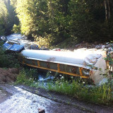
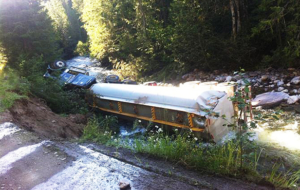
An abandoned tanker carrying jet fuel for forestry helicopters battling summer fires lays overturned, leaking 33,000 litres of toxic fuel into the Slocan Valley’s Lemon Creek
by Nelle Maxey
It was a beautiful day.
The day was Friday July 26. It was just like any other sunny summer day in the Slocan Valley, located in the West Kootenay region of British Columbia 650 kilometres east of Vancouver.
It was the height of the tourist season. Bed and breakfasts, restaurants, and retail stores were swollen with visitors. Kayaks, canoes, rafts and tubes filled the Slocan River as swimmers cooled themselves at public and private beaches along the river. Others were in their gardens, assessing if the beans were ready for canning and the garlic ready for digging. People picked raspberries and blueberries from the loaded bushes, dug potatoes, plucked zucchini, and lettuce for dinner. It was a bumper year for gardens in the valley. Farmers were in their fields cutting hay. Market gardeners and local greenhouses irrigated their crops and picked produce to sell.
All this of course was normal. What wasn’t normal, however, was the drone of helicopters flying over the Slocan Valley’s Winlaw area, dumping water scooped from the river on the two-day old Perry Ridge fire.
Then disaster struck the Slocan Valley.
At about 1:30 p.m., a large tanker truck delivering jet fuel for the Ministry of Forests fire-fighting helicopters tumbled into Lemon Creek and dumped 33,000 litres of jet fuel into the swift-flowing creek which joins the Slocan River downstream of the spill.
The driver was on the wrong road. If the driver was on the right road, they would have used Uris Road north of the Lemon Creek bridge. The tanker was on Lemon Creek Road south of the bridge. This stretch of road is a narrow, decommissioned logging road that had been closed to traffic due to slides and crumbling banks.
In the official record of what happen, one report says the driver was to meet forestry personnel who would direct them to the helicopter staging area. This never happened. Instead, the driver proceeded on his own up Lemon Creek Road, past two signs that indicated the road was closed. The driver eventually found a place to turn around and was on his way back down to Highway 6 when a road bank gave way under the weight of the tanker.
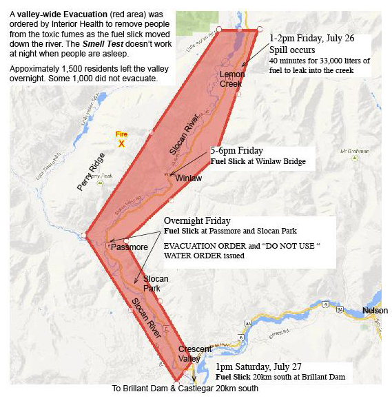
The driver, not seriously injured after the accident, scrambled up the 15-foot bank and walked the 6 kilometres back to Highway 6 where a passing vehicle picked him up so he could report the accident. RCMP arrived on the scene at approximately 3:30 p.m. in the afternoon, although the fumes were so bad they could not approach the area. Once it was confirmed the truck was carrying jet fuel, the Interior Health Authority was notified at 6 p.m. on Friday evening. A few hours later, the first evacuation order was issued for 800 residents within 300 meters of Lemon Creek and the Slocan River for 3 kilometres upstream and downstream of the spill. It took many hours before the volunteer firemen and search and rescue teams could be organized to notify residents of the evacuation order. The first phone calls went out around midnight with volunteers going door-to-door in the most affected areas.
Meanwhile back at the spill site, officials estimate the tanker released the 33,000 litres of fuel in about 40 minutes. The fuel slick reached the Winlaw Bridge sometime around 6 p.m. (about the same time the local health authority was notified of the accident). Children swimming in the river near Appledale just north of Winlaw were later reported to have skin rashes. People who were canoeing in the area also reported health effects. Residents along the river between Winlaw and Lemon Creek reported that the smell was so strong by 5 p.m. that they closed up their homes and left the area. Within 24 hours of the accident the slick had traveled 60 kilometres: down the Slocan River, then into the Kootenay River to just above of the Brilliant Hydroelectric Dam at Castlegar. The first boom to stop the slick was established there on Saturday afternoon.
The plume was 2 to 3 kilometres long and 30 to 50 metres wide. A Ministry of Environment spokesperson said a boom was put in place at about 1:30 p.m. on Saturday just above the Brilliant Dam. The spokesperson said the boom’s effectiveness in containing the fuel was being monitored. Officials didn’t know at this time if fuel had entered the dam works.
The evacuation
Within hours of the first evacuation notice issued by the Interior Health Authority, the evacuation was expanded to include everyone in the valley. Anyone living within a 3 kilometre radius of the river between Lemon Creek and Playmore Junction (where Hwy 6 joins Hwy 3 to Nelson and Castlegar) were to evacuate. This affected 2,500 residences. As the fuel progressed down the river, health authorities had become worried sleeping people would not smell the fuel.
People with emergency services and volunteer fire departments began making phone calls and knocking on doors. The evacuation order included a “Do Not Use Water” order to “all users of water supplies within 10 kilometers downstream of the spill.” Later, the wording of the order changed to suggest water wells were okay to use. This was revised again to say shallow wells near the river might be affected. Today, a week after the accident the order explains that if your creek surface water or well water doesn’t smell like jet fuel, then it’s okay to use. Essentially, a smell test was the only test for private water supplies that didn’t originate from the rivers or Lemon Creek. The evacuation order also contained the following statement: “Jet fuel poses an immediate health risk to people. Exposure can burn skin, inhalation can harm respiratory systems and may cause brain damage. It is also dangerous to consume.”
The boundaries of the evacuation and a timeline of events are shown below:
Fifty volunteer fire fighters from the four valley fire departments worked overnight and into Saturday to notify residents of the evacuation. Even though they had help, they concentrated on people closest to the river and spill site. They notified over 800 residents in all. Much of the notification went by word of mouth to neighbours, family and friends, all of which took place at night. Many residents in the north end of the valley left even before the order was issued due to the heavy concentration of fumes.
By noon on Saturday, the fumes had dissipated enough to lift the evacuation order. Residents trickled back into the valley all day Saturday. Unfortunately, at the north end of the valley some people returned to homes that were saturated with the smell of fuel. Even people’s gardens and hay fields were contaminated, not to mention the watering tanks for livestock had a layer of fuel on top of the water.
By this time, people in the valley settled down and most residents assumed the scare was over. Then the town hall meeting was held.
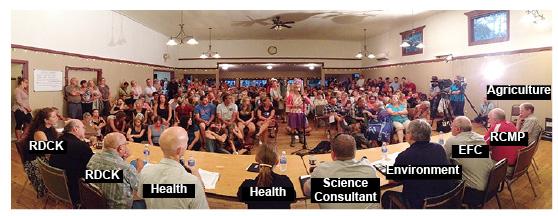
Many questions, few answers
On July 30, hundreds of residents from all areas of the valley jammed Winlaw Hall for a meeting to hear presentations from local government officials, provincial authorities and employees from the company involved. The meeting was not well organized. The handouts did not contain contact information or the names of the speakers. At first, many residents did not have their questions answered as they were told they were not on topic. Then the format was changed and residents were allowed to ask questions of any panellist. Many questions required responses from multiple panellists.
The health official immediately declared the serious nature of this event and explained the reasons for the evacuation. Though benzene was not a component of the jet fuel spilled in the creek, kerosene was a component and is dangerous by skin contact or ingestion. This applies to humans and animals. Aquatic life is at special risk as the specific type of fuel spilled (Jet Fuel A1) is listed to have a chronic toxic effect on aquatic ecosystems.
Residents were informed the “Do Not Use Water” order would stay in effect for 5 to 10 days at a minimum. The order applied to recreation in the river as well as water use from the river and Lemon Creek. All such water systems should be shut down so the contaminated water is not drawn into pipes and hot water heaters. Other surface water users from the creeks not affected directly should use their own judgement and apply the “smell test” to their water. Deep wells were unlikely to be affected. Shallow wells along the river should not be used as they may be contaminated.
This was the first time some residents heard the information about shallow wells and surface creeks. Individual water licence holders or well owners would not receive assistance to have their water tested. Registered purveyors on water systems with more than two users could receive assistance to have water testing done. Residents were also told to wash all vegetables 3 times for 3 minutes before use with potable water (a Catch-22 for residents without potable water supplies), and were also told not to buy local produce.
As residents poured into the line-up for the mic and began asking questions and sharing their stories, the consequences of the spill and the fact that little help had been available were becoming more apparent. The problems associated with the spill were most severe at the north end of the valley, from Lemon Creek to Winlaw. Homes were contaminated with the fuel smell. Fruit trees and vegetables were contaminated. Hay fields and pastures were contaminated. No water was available for livestock, poultry or gardens.
Many people were without any water for drinking, washing dishes, flushing toilets or showering. Similar water problems prevailed all along the river to the lower valley – especially contaminated hay and pastures, no water for gardens and livestock, as well as difficulty hauling enough water from potable water tank stations for resident needs. The meeting was held five days after the spill and potable water tanks had been set up in four locations in the valley only on the day of the meeting.
As of Saturday, August 3, the water and the rocks in Lemon Creek still smelled of jet fuel. There was a sheen visible and emulsion (milky-looking jet fuel and water mix) under rocks in the creek at the Lemon Creek bridge on Highway 6. The road has been remediated just before the accident site where fuel spilled from the tanker. There is no fuel on the road at the actual location where the truck went off. There is water from seeps in the rock face running across the road at that location. You can see this water in published photographs. Workers at the site agreed that the water run-off contributed to weakening the bank that collapsed under the truc, resulting in the fuel spill.
Recent developments:
Until further notice, a “Do Not Use” order for drinking water and recreational use remains in effect for Lemon Creek, Slocan River and Kootenay River above and below Brilliant Dam. Fuel is still visible in the containment booms and along the shoreline.
Garden vegetables, fruit, eggs, and dairy milk that were contacted by the fuel vapor are SAFE to consume as long as they do not smell like fuel or have a fuel sheen. Interior Health is advising residents to thoroughly wash fruit and vegetables with alternate water sources to remove any dirt and debris prior to consumption. Food products that have been irrigated with contaminated water AND smell like fuel should be discarded.
Aproximately 1,000 litres of contaminated material has been recovered.
RCMP have issued Vessel Operating Restrictions for the Slocan River from Lemon Creek to the Kootenay River, which will be lifted when the clean-up has been completed.
The smell of jet fuel is still apparent in the Lemon Creek area and responders equipped with gas monitors have been testing the air quality outside residences close to the spill site.
Many residents in the valley are still waiting for promised testing.
A Resiliency Centre is being established at the Winlaw Elementary School to support residents with shower, lavatory and emergency support services. It is expected to open within the next couple of days.
Polaris Applied Sciences from Kirkland, Washington was hired to conduct a Shoreline Clean-up and Assessment Technique, or SCAT. Leading the SCAT team is Polaris principal, Dr. Elliott Taylor, a world-renowned expert in spill clean-up operations. The assessment is underway and is already providing additional information which is helping to clean up the waterways by providing operational focus to the response teams and prioritizing where we focus our attention.
Light “flushing” activities are being conducted to free product (Jet Fuel A1 / without additives) from stream banks and vegetation to make it available for collection. Nearly 1,000 metres of containment boom has been deployed throughout the Slocan River system and it is capturing any free-flowing product. The product is being skimmed off the water into a vacuum truck and removed to a licensed waste facility. In areas where soil is impacted, the soil is being removed and trucked to a separate licensed waste facility. A significant amount of contaminated water and soil was recovered.
Experts continue to collect water samples, sediment samples, and fish and wildlife from the impacted water courses. Wildlife mortalities to date have been collected and sent to the laboratory for analysis.
Water quality test results are being sent to the Interior Health Authority to assist in making a decision on when the “Do Not Use Water” order may be lifted.
Responders equipped with gas monitors have been testing the air quality throughout the area of potential and observed influence. To date, atmospheric concentrations have been within established government standards; however, the smell of jet fuel is still occasionally apparent.
Nelle Maxey is a grandmother who lives in the beautiful Slocan Valley in south-eastern BC. She believes it is her obligation as a citizen to concern herself with the policies and politics of government at the federal, provincial and local level.