Category Archives: WATER

Why the New ‘Golden Age of Oil’ Has Been a Bust

Share

Read this story from alternet.org on the various environmental and economic factors restricting the development of “extreme energy” – from fracking to shale oil and bitumen. (Oct. 4, 2012)

To reach their ambitious targets, energy firms will have to overcome severe geological and environmental barriers — and recent developments suggest that they are going to have a tough time doing so.

Last winter, fossil-fuel enthusiasts began trumpeting the dawn of a new “golden age of oil” that would kick-start the American economy, generate millions of new jobs, and free this country from its dependence on imported petroleum. Ed Morse, head commodities analyst at Citibank, was typical.  In the Wall Street Journal he crowed, “The United States has become the fastest-growing oil and gas producer in the world, and is likely to remain so for the rest of this decade and into the 2020s.”

Once this surge in U.S. energy production was linked to a predicted boom in energy from Canada’s tar sands reserves, the results seemed obvious and uncontestable.  “North America,” he announced, “is becoming the new Middle East.”  Many other analysts have elaborated similarly on this rosy scenario, which now provides the foundation for Mitt Romney’s plan to achieve “ energy independence ” by 2020.

By employing impressive new technologies — notably deepwater drilling and hydraulic fracturing (or hydro-fracking) — energy companies were said to be on the verge of unlocking vast new stores of oil in Alaska, the Gulf of Mexico, and shale formations across the United States.  “A ‘Great Revival’ in U.S. oil production is taking shape — a major break from the near 40-year trend of falling output,” James Burkhard of IHS Cambridge Energy Research Associates (CERA) told the Senate Committee on Energy and Natural Resources in January 2012.

Increased output was also predicted elsewhere in the Western Hemisphere, especially Canada and Brazil.  “The outline of a new world oil map is emerging, and it is centered not on the Middle East but on the Western Hemisphere,” Daniel Yergin, chairman of CERA, wrote in the Washington Post .  “The new energy axis runs from Alberta, Canada, down through North Dakota and South Texas… to huge offshore oil deposits found near Brazil.”

Extreme Oil

It turns out, however, that the future may prove far more recalcitrant than these prophets of an American energy cornucopia imagine.  To reach their ambitious targets, energy firms will have to overcome severe geological and environmental barriers — and recent developments suggest that they are going to have a tough time doing so.

Consider this: while many analysts and pundits joined in the premature celebration of the new “golden age,” few emphasized that it would rest almost entirely on the exploitation of “unconventional” petroleum resources — shale oil, oil shale, Arctic oil, deep offshore oil, and tar sands (bitumen).  As for conventional oil (petroleum substances that emerge from the ground in liquid form and can be extracted using familiar, standardized technology), no one doubts that it will continue its historic decline in North America.

The “unconventional” oil that is to liberate the U.S. and its neighbors from the unreliable producers of the Middle East involves substances too hard or viscous to be extracted using standard technology or embedded in forbidding locations that require highly specialized equipment for extraction.  Think of it as “ tough oil .”

Read more: http://www.alternet.org/environment/why-new-golden-age-oil-has-been-bust

Share

Audio: Damien Gillis Discusses ‘Keepers of the Water’, Carbon Corridor on SFU Radio

Share

Damien Gillis discusses the resistance to the Enbridge pipeline, the recent “Keepers of the Water” conference in Fort Nelson, BC, and the increasing impacts on water, human and animal health from natural gas hydraulic fracking with CJSF’s Sylvia Richardson. The pair also touch on Damien’s documentary film project Fractured Land, currently in production, which examines these issues and the concept of “Canada’s Carbon Corridor” – an interconnected web of fossil fuel and mining projects throughout northern Alberta and BC, designed to open up new markets in Asia – told through the eyes of a young First Nations law student. (Oct. 6 – 20 min)

Share

US Geological Survey Confirms Fracking Contaminated Groundwater

Share

Read this story from Reuters on a new study from the US Geological Survey confirming earlier tests results that showed natural gas fracking operations contaminated groundwater in Wyoming. (Sept. 28, 2012)

SALMON, Idaho, Sept 28 (Reuters) – Government testing of a drinking water aquifer near a tiny Wyoming town has shown concentrations of gases like ethane and propane and diesel compounds, but a natural gas company said it did not cause the contamination.

A report by the U.S. Geological Survey showed petroleum-based pollutants in samples from a monitoring well in the aquifer adjacent to Pavillion, Wyoming, which is at the center of a national debate over hydraulic fracturing, or fracking.

A draft study released in December by the Environmental Protection Agency linked fluids used in fracking, a drilling method that has unlocked vast shale gas deposits across the nation, to pollution in the underground formation that supplies drinking water to residents near Encana Corp’s gas production wells east of Pavillion.

The findings contradicted claims by gas drillers that fluids from fracking, which injects water, sand and chemicals underground to boost extraction of fuel, have never contaminated drinking water.

Criticism by the oil and gas industry and Wyoming officials of the methods the EPA employed to collect water quality data and regulators’ interpretation of the findings prompted recent retesting under a monitoring plan designed by the state, the USGS and the EPA.

Compared to the 2011 EPA study, the USGS results from testing of one of two monitoring wells in the aquifer indicated higher levels of gases like methane, lower levels of diesel-range organics and the absence of such solvents as toluene, an Encana analysis showed.

The EPA is expected in coming days to release its testing of water from two groundwater monitoring wells, several domestic wells and a public well. The data sets are to be submitted for peer review.

The EPA said the groundwater monitoring data in its 2011 report and USGS findings were “generally consistent.”

But Encana spokesman Doug Hock said the findings are not equal and singled out USGS for providing “credible data” in research whose “implications are not just for Encana but for the whole industry.”

Hock and Simon Lomax, research director of an arm of the Independent Petroleum Association of America, underscored a decision by USGS to discount samples from the second of two monitoring wells because of concerns that low water quantity and other factors might skew results.

“The USGS effectively disqualified one of the EPA’s two monitoring wells,” Lomax said in a statement.

He pointed to a March 1 letter by Donald Simpson, director of the Bureau of Land Management office in Wyoming, that recommended the installation of additional monitoring wells for a “larger and much more robust study effort and investment prior to drawing any conclusions, particularly in the case about the role of hydraulic fracturing use in development of the oil and gas resource.”

Encana’s Hock said the Canadian company denies the pollution in Pavillion is related to its operations.

But Rob Jackson, professor of environmental sciences at Duke University, said his review of USGS data shows it is consistent with EPA’s initial results, “which suggested the contamination at the site from fracking is a real possibility.”

Jackson, co-author of a peer-reviewed paper that showed fracking in the Marcellus shale in Pennsylvania did not pollute adjacent drinking water wells with brine, said the report by the USGS should quiet criticism of the EPA.

“You can’t say that EPA botched the job if USGS goes on and gets similar numbers,” he said.

Read more: http://www.huffingtonpost.com/2012/09/29/usgs-aquifer-tests-pavillion-wyoming_n_1924604.html

Share
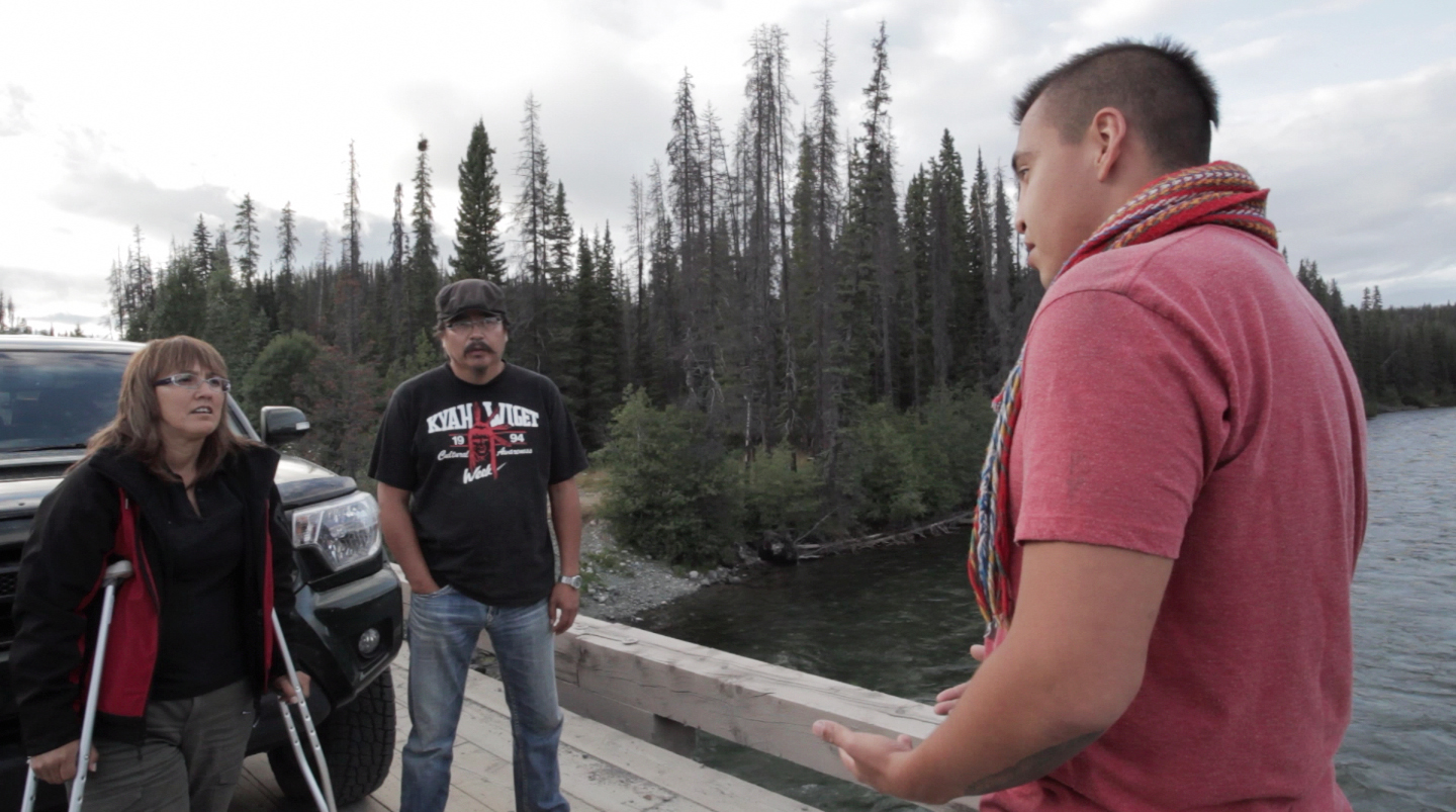
Caleb Behn, the subject of the forthcoming film

Canada’s Carbon Corridor Part 2: From the Sacred Headwaters to Kitimat LNG

Share

The following is the second half of the introduction to Damien Gillis’ multi-part series, “Canada’s Carbon Corridor”read part 1 here.

In part 1 of this introduction to what my colleagues and I have termed “Canada’s Carbon Corridor” – an interconnected web of major oil, gas, coal, mining and hydroelectric projects across northern BC and Alberta – I traced the first half of a recent journey by the team producing the documentary Fractured Land, of which I am the co-director. We began our trip amidst proposed coal mines and Site C Dam on the Peace River and through the heart of natural gas “fracking” operations in northeast BC, winding up at Liard Hot Springs.

From there, after passing briefly into the Yukon via the Alaska Highway, we turned south and headed for Tahltan country in northwest BC. There, we spent four days investigating proposed mining projects and more unconventional gas – this time Shell’s plans to develop coal bed methane in the Sacred Headwaters, the birthplace of three vital arteries for the province, the Skeena, Nass and Stikine Rivers.

We spent one day with Wade Davis, National Geogrpahic Explorer-in-Residence and recent author of the book Sacred Headwaters, and the rest of our time with a number of First Nations who have put themselves on the line to block coal bed methane and mines like Imperial Metals’ proposed Red Chris.

This particular project would involve a massive mountaintop removal mine for gold and copper, amid the continent’s largest population of Stone’s Sheep. As such, it has ignited much local opposition. But we also learned that there are many members of the various Tahltan communities who are in favour of this and other mines for the jobs and economic opportunities they promise. This conflict will likely play out for some time to come in these communities, though the tide may be turning against Red Chris for a number of reasons, which I’ll get into in a future chapter of this series.

From the Sacred Headwaters, we travelled south to Kitimat, documenting along the way the construction of the Northwest Transmission Line. This $400 million project is designed to plug BC’s electrical grid into the region in order to power these mining projects – of which Red Chris is but one of many. (Which is why it’s odd that a significant portion of the line’s funding came by way of a federal “green energy” fund!). The transmission line is yet another connection between northwest BC and the proposed Site C Dam in the territory of our central character Caleb Behn – which our provincial government justifies with the contention it is needed to provide power to gas and mining operations.

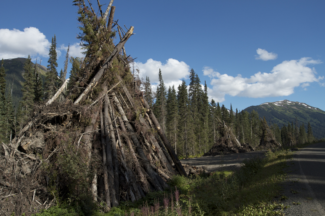
We were all alarmed at the pace of development of the transmission corridor, with upwards of ten different crews working simultaneously to clear sections of the line – carving a 100 or so meter-wide swath through spectacular mountain valleys. Fifty-foot tall teepees of logged trees rim the highway for long stretches, waiting to be burned.

In Kitimat, we met with former Haisla elected chief and recent president of the Coastal First Nations, Gerald Amos, to get a look at the LNG plants proposed and under construction in his territory, along the Douglas Channel. Gerald and his wife graciously took us out on their boat to show us the three main proposed projects – one led by Shell, with partners Korea Gas Corporation, Mitsubishi Corporation and PetroChina Company Limited; another by a consortium of Encana, Apache Canada and Enron Oil and Gas (known as Kitimat LNG); and the third a joint venture in which the Haisla Nation itself is a partner. (It should be noted there are as many as eight LNG plans for Kitimat, but these three would appear to be the most serious and viable).

Only the Kitimat LNG project is under initial construction – clearing the banks of the channel of trees and brush – though its completion has been pushed back by a year, as the consortium has yet to sign any contracts for the product.

Meanwhile, the Haisla just signed a deal with the province to expedite their plant. While his elected leadership is moving quickly forward with its plans to welcome LNG into their territory, Gerald was eager to hear from Caleb about how these decisions will affect his people at the other end of the pipeline. This is some of the much-needed dialogue currently missing around these issues, which we hope our project will continue to foster.

While the Haisla have led the battle against the proposed Enbridge pipeline on their lands and supertankers in their waters, natural gas has proven a different story. Deals signed by the Haisla and the Carrier-Sekani Tribal Council, which provides political and technical support to eight member First Nations in the northern BC interior, appear to have been done with far less communication with other First Nations and the public than that which surrounded Enbridge.

We learned the Carrier-Sekani signed last year a 25-year deal estimated to be worth over $500 million in shared revenue and job training benefits with the proponents of the Pacific Trails Pipeline, which would carry fracked northeast BC gas from a junction point at Summit Lake, north of Prince George, to Kitimat, along virtually the identical right-of-way as the proposed Enbridge Pipeline.

On that note, during one of our final stops on the trip, we visited the grassroots resistance camp on the Morice River, southwest of Houston, where members of one clan of the Wetsu’et’en First Nations, the Unist’ot’en, have constructed and are occupying a cabin directly in the path of the proposed Pacific Trails Pipeline. But as they pointed out to us, they’re not opposed to just one pipeline, rather as many as eight different ones, each proposed to pass through essentially the same energy corridor:

  • Enbridge’s twin lines – one for diluted bitumen, the other for condensate
  • Kinder Morgan’s “Rearguard” bitumen pipeline to Kitimat – introduced last year to shareholders as a backup plan to the controversial Enbridge Northern Gateway line and to Kinder’s own plans to twin its existing Trans Mountain Pipeline to Vancouver (the Unist’ot’en camp is prepared for this line to include a twin condensate line as Enbridge is proposing)
  • Pembina Pipelines has a plan – temporarily shelved for “commercial uncertainties” – to run a condensate line from Kitimat to Summit Lake (the Unist’ot’en camp is bracing for this plan to come to the fore again should Enbridge be rejected, and for the possibility it too will include a bitumen line) 
  • The Pacific Trails gas pipeline (already approved by the province, along with the related LNG plant in Kitimat)
  • Shell Canada and its Asian partners’ gas pipeline from northeast BC to their proposed LNG facility in Kitimat (Shell has already selected TransCanada Pipelines to build this line)

Moreover, Spectra Energy recently announced plans to run a gas line to Prince Rupert, north of Kitimat, to connect to their own proposed LNG plant and tankers there.

Is this somehow a conspiracy theory? Hardly. I reported in The Common Sense Canadian over a year ago that Enbridge CEO Pat Daniel has publicly expressed interest in exploiting pipeline “right-of-way synergies”, in building both its twin pipelines and the Pacific Trails gas line together. Enbridge also bought Encana’s controlling stake in the Cabin Gas Plant in Northeast BC last year. And the proposed routes of the above pipelines essentially stack on top of each other for long stretches.

My concern is that while all this attention is being payed to Enbridge, virtually no one – amongst First Nations, the conservation community, or the political opposition (the NDP has publicly supported fracking, the Pacific Trails Pipeline and LNG projects in Kitimat and is at best on the fence about Site C Dam) – is talking about this larger energy corridor, of which Enbridge is merely one small piece.

The Pacific Trails line is approved and the companies are into pre-construction work already. Once the corridor is logged and cleared, it will be far more difficult to stop any one, let alone all of these pipelines and the development to which they connect.

From Site C Dam, powering gas and mining operations, to expanded fracking, which connects to the Alberta Tar Sands through natural gas and condensate, to oil and gas pipelines to our coast and the tankers that would transit our waters carrying these fossil fuels – bitumen, LNG, coal – to new markets in Asia, this is a big deal. The biggest, by far, that this province has ever seen in 150 years of colonial establishment.

It’s time we expand our horizons and broaden our discussion beyond Enbridge – and our team hopes our Fractured Land film project and subsequent columns in this series will act as a catalyst for that much-needed dialogue.

Thanks to Rivers Without Borders for their support with this portion of our recent filming tour for Fractured Land.

Watch for part 3 of the “Canada’s Carbon Corridor” series on this past week’s “Keepers of the Water” conference in Fort Nelson.

Share

Gwen Barlee Op-Ed: Lifting the ‘Green Cloak’ that Covers Private River Power Projects

Share

Read this op-ed in the Vancouver Sun by Gwen Barlee of the Wilderness Committee, pulling back the ‘green cloak’ that masks the economically and environmentally destructive nature of private river diversion projects in BC. (Sept. 17, 2012)

When I was growing up my mother used to warn me to look out for a wolf in sheep’s clothing. What she meant was to be cautious about people and situations that are not what they seem. This idiom aptly applies to the issue of independent power projects (IPPs) in British Columbia.

At first blush IPPs, notably river diversion projects, seem like a visionary and green solution to producing low carbon energy. Indeed, this is what the Wilderness Committee, a BC-based environmental organization, first thought when we were introduced to the concept a decade ago, and it is what the IPP industry vigorously advocates, as evidenced in Paul Kariya’s commentary to The Vancouver Sun on September 3rd.

Unfortunately, the reality is far different.

History shows that IPPs took root in BC when the provincial government introduced an energy policy in 2002 which forbade BC Hydro from producing new sources of hydroelectricity. This led to over 800 creeks, rivers and even lakes being “staked” by private power companies who were eager to capitalize on the rich electricity contracts BC Hydro was forced to issue. The move to stimulate IPPs in BC had nothing to do with tackling climate change, as the BC government at that time actively opposed the implementation of the Kyoto Protocol. Instead, it had to do with electricity privatization and deregulation – twin concepts sweeping North America at the time.

Today, because of a horribly misguided energy policy, BC Hydro is now on the hook for over $50 billion – yes, billion – in sweetheart energy purchase agreements to IPPs. It is important to remember that IPP electricity produced here was never meant for BC. It was slated for California, except California doesn’t consider river-diversion projects to be green and it won’t pay a premium for the power.

So here we sit, with a publicly-owned utility saddled with an enormous debt for power we don’t need. BC Hydro, once the envy of North America for providing our province with reliable low-carbon electricity, now hovers on the edge of bankruptcy unless it can pass on its considerable debt to ratepayers.


Share
Caleb Behn, the subject of the film

‘Canada’s Carbon Corridor’ Part 1: Connecting the Dots Across Northern BC

Share

I recently returned from a whirlwind tour across northern BC, one of many legs of filming for a documentary and multi-media project I’ve been co-directing for the past year and a half, called Fractured Land. The people we spoke to along the way, the sights we witnessed and documented finally brought into focus the real story about energy development in BC.

It is clear to me that the proposed Enbridge Pipeline, which has been the target of so much activism and media attention of late, is merely one piece of a much bigger puzzle that promises to transform this province like nothing since the days of colonial, railroad-driven “nation building.”

Our film and the multi-media series that will accompany it through our website, FracturedLand.com, and various social media tools, is the story the industrialization of northern BC – told through the eyes of a talented, eloquent young First Nations law student named Caleb Behn.

The two sides of Caleb’s family are rooted in the epicentres of both major natural gas hydraulic fracturing (or “fracking”) plays in northeast BC – West Moberly Territory near Hudson’s Hope, under which the Montney shale gas field extends; and Echo Dene Territory around Fort Nelson, home of the Horn River shale gas field. Taken together – along with the recently discovered neighbouring Liard Basin play – form one of the world’s meccas for “unconventional” gas (read: highly experimental and dangerous).

We began our film by focusing on fracking – a relatively new method of natural gas extraction that involves burrowing deep into shale formations and blasting them with a toxic mixture of high-pressure water, chemicals and sand to crack open the shale and release the gas. But throughout our adventure, we’ve come to see that fracking doesn’t exist in isolation. Neither does the proposed Site C Dam on the Peace River in the same region, nor gas and bitumen pipelines proposed to cut across BC’s wilderness en route to Kitimat and Prince Rupert, nor myriad, massive proposed Liquified Natural Gas (LNG) plants on BC’s coast, nor the dozen or more serious coal and metals mines proposed throughout the north, nor the Alberta Tar Sands.

It is a serious mistake to put any of these projects in a silo. They are all, in fact, systemically interconnected in what my colleagues and I have come to think of – at least until a more apt description emerges – as “Canada’s Carbon Corridor”. Before this article and its second part conclude, I will briefly illustrate this interconnected web of energy projects that extend from BC’s coast to the Alberta Tar Sands – covering virtually the entire top half of the two provinces. However, the real work of fleshing out the components of this carbon corridor and how each piece relates to the next will be accomplished through a subsequent series of stories over the next two months – each exploding a different piece of the big puzzle – all cross-published through The Common Sense Canadian and the blog for Fractured Land.

Both this film project and my colleagues at The Common Sense Canadian – which has made its mission to inform the public about the energy, environmental and public policies reshaping BC and Canada – will seek to lodge this big picture view, with all its socioeconomic and cultural implications, on the agenda of the public and media in the lead-up to a pivotal provincial election next May. This is a sorely needed conversation that so far has been lost in the simplistic rhetoric championing the project of opening Western Canadian oil and gas resources to new markets in Asia and the one-track chorus of opposition to the Enbridge proposal.

If that seems unfair, allow me to state my case herewith.

We began our recent two and a half week journey in northeast BC, before traveling along the Alaska Highway through Fort Nelson, Liard Hot Springs, Watson Lake just over the Yukon Border, then down Highway 37 through the Sacred Headwaters and Tahltan First Nations country, southwest to Kitimat, east to the Morice River near Houston, and finally to Prince George to deliver a presentation to faculty and students at UNBC, before heading home to Vancouver (an approximately 5,000 km journey, all told).
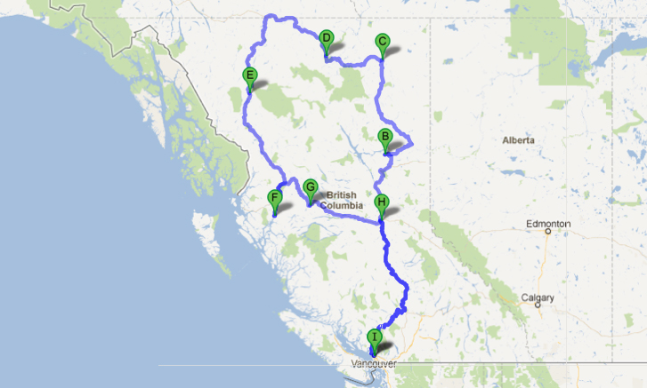
Over the past several years, I’ve made seven trips to northeast BC (I’m currently here again for the “Keepers of the Water” conference in Fort Nelson) and more than that to northwest BC and its coast, but this trip – as it tied together both sides and centres of development in the province – felt like the quintessential journey through BC’s proposed economic future. Through it, we traced the interconnections of this carbon corridor and met people on both sides of the arguments around these individual projects.

If there’s one thing that has become abundantly clear to our production team, it’s that this is a conversation which defies easy polarities. The fracturing we reference in our title, taken literally from the process of fracking, serves as a metaphor for the conflict within individuals, families and communities torn between developing economic opportunities and protecting their core values  and ancestral practices on the land.

Far from shying away from this tension, we are drilling deep into it.

After driving 15 hours north from Vancouver, we began our experience at Carbon Lake, near Hudson’s Hope – at a camp once owned by my great uncle, Penn Powell, who operated it as a fly-in fishing lodge for years. Today, it is owned and operated by the Saulteau First Nation – the people of our central character Caleb’s grandmother.

Caleb comes here in the summer to hunt moose and reconnect with his land. Unfortunately, the moose are slim pickings these days – likely partly related to all the roads for logging that bisect the onetime wilderness surrounding the lake. Now, a large open pit coal mine threatens to finish the job. Carbon Lake gets its name for a reason. One can pick up large blocks of metallurgical-grade coal from the bed of nearby Carbon Creek, the site of one of a number of proposed new coal mines throughout the Peace River Coalfield.

To get to the lake, we had to drive over Williston Reservoir and WAC Bennett Dam – the first major dam in the region, which helped set the stage for the resource boom that followed. Caleb and my families have much in common beyond this camp at Carbon Lake, as we’ve learned throughout the making of our film. Another thing we share is that both our families lost our land in the flooding of Williston Reservoir in 1968. My family’s land, upon which it settled in 1914, was known as Goldbar Ranch at 20 Mile. Today, many of my uncles who remain in the region work in the gas patch. As do many of Caleb’s relatives. Such are the complexities inherent in the sort of large-scale resource decisions being made today – mostly without the broad-based knowledge and will of the public.

That said, Bennett Dam was built to provide affordable, “clean” (or so we thought at the time) electricity and new economic opportunities for all British Columbians. I believe my family understood that, even as we watched our barns and hand-crafted cabins and grand old log home burned to the ground and drowned forevermore.

Today, two fracking companies – Talisman Energy and Canbriam Energy – have a 20-year license to suck 10 million litres a day of water from that same reservoir (before it’s converted to power for British Columbians!) for their nearby fracking operations.

Moreover, Site C – which would be the third dam in the Peace Valley, stretching 80 km east from Hudson’s Hope to Fort St. John and flooding some 13,000 acres of agricultural land and a comparable amount of Boreal Forest wildlife habitat – is not being proposed to power BC’s homes and businesses. We have access to plenty of electricity for those purposes. Rather, this power will go to the myriad proposed mining operations across the north and, according to Premier Christy Clark, compressing natural gas into liquid to sell to Asia. All of these industrial operations are enormously energy dependent – to the point we would need multiple Site C Dams to even begin powering them.

From Carbon Lake, our team traveled north to Fort Nelson, where we visited with the other side of Caleb’s family. Fort Nelson is the jumping off point for the Horn River shale gas operations, which have been slowing down of late, due to the cratering price of natural gas, but contain enormous development potential and have been wildly active in recent years. The Cabin Gas Plant, North America’s largest, is just nearing completion after several years of furious construction. The adjacent Liard Basin formation was recently touted by Apache Canada as “the best reservoir in North America” for gas fracking.

Yet little of this development will occur unless a higher price can be obtained for the resource. This relatively new method of fracking has flooded the North American market with supply, driving down the price for gas, which is why new markets are being sought in Asia, where gas prices are currently much higher.

Unlike the gas plays around Fort Nelson, the Montney play – in Caleb’s mother’s territory, where we began our journey – often produces what is considered as “wet gas”, meaning it contains other products, such as sulfur and condensate, both of which have considerable value on their own. Condensate is used to dilute bitumen from the Alberta Tar Sands, which is too viscous to pump through a pipeline on its own.

This is another way in which Canada’s Carbon Corridor is interconnected – both natural gas and condensate go from BC to Alberta to melt and extract bitumen and to dilute it for transport.

But the big idea, for now, is to open up new markets for northeast BC gas. If these LNG plants and the pipelines connecting northeast BC gas to northwest BC refineries proceed, you can bet Horn River activity will ramp up to new heights and the Liard Basin will be cracked wide open.

We drove near these proposed Liard operations en route to the northwest corner of the province and it is some of the most exquisite country any of us has seen. We passed through pristine valleys coursing with crystal-clear water from the Northern Rockies and by herds of majestic wild bison and various ungulate species. Our soak in the Liard Hot Springs was one the trip’s big highlights – I would highly recommend it to anyone who finds themselves in that neck of the woods.

Watch for Part 2 of this introduction to Damien Gillis’ “Canada’s Carbon Corridor” series Saturday – completing the journey across northern BC to the northwest, examining everything from mining and unconventional gas proposals in the Sacred Headwaters to the construction of the Northwest Transmission Line, the Pacific Trails gas pipeline to Kitimat and proposed LNG facilities there.

Share
Photos courtesy of Valhalla Wilderness Society

Action Urged to Protect Ancient Incomappleux Valley from Proposed IPP

Share

The Valhalla Wilderness Society of the Kootenays is urging citizens to send a message today to the provincial government in opposition of a proposed private power project on the spectacular Incomappleux river.

The province’s Integrated Land Management Bureau (ILMB) is accepting comments from the public until midnight tonight (Sept. 20) on private power titan TranAlta’s application to carry out potentially damaging feasibility studies for a proposed private river diversion project on the Incomappleux, considered one of BC’s most intact old growth rainforest valleys.

According to Valhalla:

The upper Incomappleux River and its very ancient rainforest are the gems of the Selkirk Mountain Caribou Park Proposal.

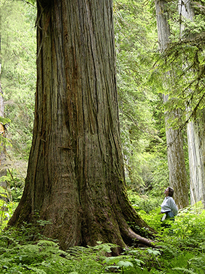
The valley has been severely logged for a major part of its length.  But the logging stopped before the end of the forest, leaving behind a five-kilometre stretch of river with very rare valley-bottom Inland Temperate Rainforest, with trees up to four metres in diameter and 1,800 years old. Scientists say this forest could have been growing undisturbed since the last ice age. It is part of a 17-kilometre stretch of wild river running through intact wilderness adjacent to Glacier National Park.

This now famous valley has drawn scientists from five countries to study the biodiversity of its ancient rainforest and its extensive wetland. They have found numerous rare species of lichens, mushrooms, snails and plants including a number of red- and blue-listed species.

The organization is concerned that even “feasibility studies” would have a detrimental impact on the highly sensitive and rare ecosystem. “The studies alone will include drilling, and possibly road building and cutting down trees to bring in heavy equipment. This will be a huge investment on the part of the proponent for a development that would then be leverage to get the IPP approved.”

Because the proposed generating capacity of this river diversion project, at 45 Megawatts, falls below the 50 Megawatt threshold, it will not require an environmental assessment from the province.

Some of the key environmental concerns from the project include the diversion of a significant amount of water from the river for an 8.8 km stretch, through prime Grizzly habitat, industrial roads being constructed on the edge of Glacier National Park, and a 75 km transmission line, carved through prime old-growth forest.

Private power projects have been thoroughly criticized in these pages for both serious environmental problems, thoroughly demonstrated by evidence, and for their lack of financial sense for BC taxpayers and hydro ratepayers.

Concerned citizens can register their comments with the ILMB by midnight tonight through their online form.

Share

Fracking Wastewater Used in Ohio Full of Radium

Share

Read this story from the Columbus Dispatch on the discovery of radiation in water trucked from the Marcellus Shale in Pennsylvania to Ohio for hydraulic fracturing operations. (Sept. 3, 2012)

Millions of barrels of wastewater trucked into Ohio from shale-gas wells in Pennsylvania might be highly radioactive, according to a government study.

Radium in one sample of Marcellus shale wastewater, also called brine, that Pennsylvania officials collected in 2009 was 3,609 times more radioactive than a federal safety limit for drinking water. It was 300 times higher than a Nuclear Regulatory Commission limit for industrial discharges to water.

The December 2011 study, compiled by the U.S. Geological Survey, also found that the median levels of radium in brine from Marcellus shale wells was more than three times higher than brine collected from conventional oil and gas wells.

“These are very, very high concentrations of radium compared to other oil and gas brines,” said Mark Engle, a U.S. Geological Survey research geologist and co-author of the report.

State law bans radioactive shale-well sand and sludge from Ohio landfills. However, brine can be sent down any of Ohio’s 171 active disposal wells regardless of how much radium it contains. Michael Snee, the Ohio Department of Health’s radiation-protection chief, said that’s the safest place for brine.“Injection wells are almost the perfect solution for that disposal issue,” Snee said.

However, environmental advocates say the Geological Survey’s report intensifies their fears of surface spills and leaks to groundwater.

“It’s an alarm bell in the night that we better get serious about testing the material in the Utica shale right here in Ohio,” said Jack Shaner, an Ohio Environmental Council lobbyist.

Shaner and others said the study shows that state officials should look at what’s bubbling out of Ohio’s shale wells.

Radiation is yet another wrinkle in the ongoing debate over “fracking,” a process that sends millions of gallons of water, sand and chemicals down wells to shatter shale and free trapped oil and gas. Thousands of Marcellus shale wells have been drilled in Pennsylvania. Of the 12.2 million barrels of brine injected into Ohio disposal wells last year, 53 percent came from Pennsylvania and West Virginia.

Read more: http://www.dispatch.com/content/stories/local/2012/09/03/gas-well-waste-full-of-radium.html

Share
A scene from the forthcoming film 'Fractured Land'

Audio: Damien Gillis Discusses ‘Fractured Land’ Doc on SFU Radio

Share

Damien Gillis discusses the forthcoming film Fractured Land with SFU Radio’s David Swanson, along with a recent journey across northern BC to document a number of interconnected industrial projects. The film, which Gillis has been co-directing for the past year and a half with Vancouver-based filmmaker Fiona Rayher, is the story of the industrialization of northern BC told through the eyes of a young indigenous law student, Caleb Behn. It examines everything from controversial hyrdraulic fracturing for natural gas, mining and the proposed Site C Dam – all in Caleb’s traditional territory – as well as plans to pipe gas across BC and convert it to liquid to ship it to new Asian markets through the port town of Kitimat. (8 min – broadcast Sept. 17)

Watch for an upcoming “crowd-funding” campaign to generate grassroots support for Fractured Land.

Share

Fort St. John Mayor Refuses to Take a Position on Site C Dam

Share

Read this story from The Georgia Straight on Fort St. John Mayor Lori Ackerman’s “neutral” position on the proposed Site C Dam near her community in northeast BC. (Aug. 29, 2012)

The mayor of Fort St. John has said her position on the Site C dam “entirely depends on the negotiations” that are ongoing surrounding the project’s environmental assessment.

“I’m staying neutral right up until we start negotiating,” Lori Ackerman, a city councillor prior to her election to the top seat in November 2011, told the Straight by phone.

Site C would be the third dam and hydroelectric-power generating station on the Peace River in northeastern B.C. According to B.C. Hydro’s website, it could have up to 1,100 megawatts of capacity and produce about 5,100 gigawatt hours of electricity per year. The $7.9-billion project is now being subjected to a joint federal and provincial environmental review.

“The Peace River is one of two major working rivers in the province…and it is our intention to ensure that we make them [the review panel] aware that this is going to impact our community,” Ackerman said. “So we’re asking our community to reflect on how it’s going to impact their life, their quality of life, the services that they rely on, the work that they do, and give us some feedback so we can go forward to the government, to B.C. Hydro, and the joint review panel.”

Bruce Lantz, the city’s previous mayor, told the Straight in 2009 that council had not taken a position on the project.

“The official city position, which occurred prior to my time on council, was that because it’s outside our area, it really has no particular bearing, and that the city would work with Hydro to see what kind of legacies they could get from the construction of Site C—if it goes ahead,” Lantz said in a sit-down interview at the time.

Read more: http://www.straight.com/article-766386/vancouver/fort-st-john-mayor-neutral-site-c

Share