
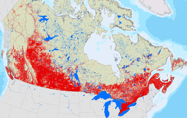
A national study suggests that Alberta has disturbed more natural landscape than any other province.
The analysis by Global Forest Watch adds that Wild Rose Country also has two of the three areas in Canada where the rate of disturbance is the highest.
“There were at least three major hotspots, two in Alberta,” said report author Peter Lee.
The report (download here) combines government data, satellite imagery and cropland maps to look at human intrusions in the last decade into all major Canadian ecozones. Those disruptions included everything from roads to seismic lines to clearcuts to croplands.
“We took all the available credible data sets that we could find and combined them all,” said Lee. “We ended up with what we believe is the best available map of human footprint across Canada.”
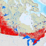
Alberta leads in the amount of land disturbed at about 410,000 square kilometres. Almost two-thirds of the province — 62 per cent — has seen industrial or agricultural intrusion.
Saskatchewan, at 46 per cent, is second among the larger provinces. Quebec comes nearest in area with 347,000 square kilometres.
The Maritime provinces actually have the highest rate of disturbance. The human footprint in Prince Edward Island, New Brunswick and Nova Scotia is 94, 85 and 72 per cent respectively of each province’s total area. But those provinces are so relatively small that the actual amount of disturbed land is dwarfed by totals elsewhere.
When Lee compared the current map to one developed about 10 years ago, he found two of three areas where the rate of development was highest were in Alberta as well — one was in the oilsands region; the other along the eastern slopes of the Rockies.
The third area is in a heavily logged part of northern Quebec. New intrusion in northeastern British Columbia, where there is extensive energy development, is almost as heavy.
Lee said development in the three top zones is pushing into previously untouched land at the rate of five to 10 kilometres a year.
The report’s calculations include a 500-metre buffer zone, which corresponds to the distance animals such as woodland caribou tend to keep between themselves and development.
Duncan MacDonnell of Alberta Environment said the government has plans to set aside about 20 per cent of the remaining boreal forest, which covers the northern third of the province.
That includes about 20,000 square kilometres in the oilsands region. MacDonnell said Alberta plans to eventually combine old and new protected areas to create the largest connected boreal conservation area in North America.
Those plans haven’t been implemented and all are the subject of controversy with area aboriginals.
MacDonnell said the province is developing land-use plans for the entire province which are intended to balance pressures on the landscape.
Representatives from the federal government were not available for comment.
Lee notes his findings come at a time when Canadian and provincial policies on development are being increasingly scrutinized, whether they involve forestry, energy or agriculture. He said this sort of basic, common-sense data-gathering should be done by Ottawa.
“It’s those sort of general questions that the person in the street asks,” said Lee. “Where are all the disturbances in Canada? Where are the pristine areas?
“This is a simple monitoring analysis that should be done and could very easily be done by the feds … (but) they’re not doing it.”
The common denominator between impacts of energy production and Canadian agriculture is that they both use industrial fossil-derived fuels. There are about 200,000 farmers in Canada vs 4 million in Nepal. The average size of farm in Nepal is 1 hectare, and they use much less fossil fuel. Ex NRCAN geologist David Hughes calculated a few years ago that it would take 8 years of human labour at minimum wage to equal the energy contained in a barrel of oil. So the oil is much more valuable in displacing direct human labour than we pay for it, yet also enables us to disturb more land than we’d otherwise do.
What matters is that we meet a science-based, down-scaled global per capita carbon budget that acknowledges how much of the global carbon sink developed nations appropriated before we even knew it was a problem.
Climate scientist Ken Caldeira estimated that each joule of fossil energy released today will trap in the order of 100,000 joules over the next 350Kyr. So we have an extraordinarily large carbon doppelganger to deal with in all sectors.
True enough, doconnor. And the map doesn’t reflect the specific nature and degree of these impacts. I would suggest oilsands and shale gas development have a heavier impact on the landscape than does agriculture – but farms, especially large-scale industrial ones, leave a big footprint too, in terms of clearing natural ecosystems, water use, fertilizer and animal waste runoff, etc.
Damien; agriculture has disturbed more land in Canada since European colonization than all other activities combined. Have you ever flown across Canada and looked out the window? The prairie and aspen parkland ecosystems have been essentially wiped out. Not so for the boreal forest, notwithstanding the development of the oil sands. http://en.wikipedia.org/wiki/Aspen_parkland#cite_note-Atlas-1 sorry for the wikipedia reference but I’m just heading out. Best. M.
I don’t dispute that for a second, megatpera. What’s your point? Are you opposed to feeding ourselves?
“I would suggest oilsands and shale gas development have a heavier impact on the landscape than does agriculture” is what I was responding to. Not opposed to agriculture at all, of course. I worry that the impact of the oil sands is what people focus on and underestimate the impact of other activities, to the detriment of the environment.
I’m still confused, megaptera. I stand by both comments – they aren’t mutually exclusive.
I accept that agriculture has disturbed more land mass than oil and gas activities. I also believe that oil and gas activities, acre for acre, exert a much heavier tool on the landscape.
What’s the issue?
The vast majority of that impact is agricultural, not industrial. Not everything is the oilsand’s fault.