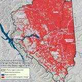
Roads, dams, logging, mines, fracking, seismic lines, pipelines, transmission lines. The Peace Valley region in northeast BC has seen its share of industrial development over the past half century. Now, a new report from the David Suzuki Foundation vividly illustrates the toll these cumulative impacts have taken on the land.
The foundation commissioned scientists from Global Forest Watch Canada to survey 40 years worth of satellite images in order track the increasing industrialization of the land. They found that over that span, more than 65% of the region has been impacted by industry – often involving different activities layered on top of each other – leaving little intact wilderness.
“Our study found that there are 16,267 oil and gas wells, 28,587 kilometres of pipeline, 45,293 kilometres of roads, and 116,725 kilometres of seismic lines packed into the Peace Region. If laid end to end, the roads, pipelines and seismic lines would wrap around the planet an astonishing four and a half times,” said Peter Lee, who led the research study.
Far from being a thing of the past, this industrialization of the region continues marching forward, with the proposed Site C Dam, new coal mines, and continued logging, fracking and other impacts. All this occurs atop important habitat for threatened populations of grizzly and caribou and amid sensitive boreal forest critical to carbon absorption and sequestration.
The Suzuki Foundation is supporting the work by Treaty 8 First Nations, farmers and conservationists to oppose Site C Dam, which would be the third dam on the Peace River. Representatives of these groups recently came to Vancouver and shared their message with local media.
“Enough is enough,” West Moberly First Nations Chief Roland Willson told The Vancouver Sun. “We need to slow down. It’s more important to maintain the integrity of what’s there than put it under water…all to expand the industrial footprint.”
Said Dr. Faisial Moola of the Suzuki Foundation in a blog on the report’s release, “If built, Site C would flood 3,173 ha of prime farmland and destroy sensitive wildlife habitat.”
“That’s why the David Suzuki Foundation is standing with local farmers and ranchers, as well as the Dunne Zaa/Dane zaa First Nations, to oppose further destruction of this productive, ecologically important and picturesque valley with the construction of the Site C Dam and reservoir.”
Download the full report here.
Damien Gillis is co-directing a documentary, Fractured Land, which examines these issues in detail. Learn how you can support the film here.


This is a very interesting study and does show what mankind has accomplished. It is not all industrial, a lot of it is societal infrastructure.
Imagine what the prairies would look like, or eastern Canada, or Europe if we went back far enough. A study like that could be done. It would take time since imagining satellites have been around for only about 50 years. We could use maps and records of habitation. What would the world look like then in this approach?
Just mind boggling what has happened. This is something the media should be jumping all over – but no ! The MSM (radio, tv and press) are all bought out by both the provincial and federal governments.
I shudder to think what western Canada will look like in twenty or thirty years – long after I have gone.
Corporations dictating how we citizens will live, while their senior management languish in luxury, oblivious to what is happening. On top of all this and to add insult to what has happened, the Chinese now flexing their muscles over the coal mine business.
Way to go Harper – ugh!
I used to be proud to be Canadian – not so much any more.
Thanks